Finding the right GPS system for trucking can improve delivery times, reduce fuel costs, and help navigate heavy-vehicle restrictions. This guide highlights top truck-focused devices with custom routing, load-to-dock features, and large displays for easy in-cab use. Each pick below is evaluated for driver safety, map accuracy, and route customization, so professional drivers can compare options quickly and make informed decisions.
| Product | Brand | Display | Key Feature |
|---|---|---|---|
| Garmin dezl OTR610 | Garmin | 6-inch | Custom truck routing with Birdseye imagery |
| Garmin Dezl OTR500 | Garmin | 5.5-inch | Load-to-dock guidance and PrePass notifications |
| Rand McNally RANDTAB7 | Rand McNally | 7-inch | Advanced Rand Navigation 2.0 with 2025 maps |
| Garmin dezl OTR720 | Garmin | 7-inch | Truck routing with satellite imagery and dock visibility |
| Navmoir GPS Navigator | Navmoir | 9-inch | Custom truck routing and 2025 maps |
Across these selections, features to watch include size-aware routing, height/weight alerts, real-time traffic data, and compatibility with 12–24V vehicle electrical systems. The devices range from compact 5.5-inch screens to expansive 9-inch displays, ensuring legibility in varying cab layouts. Where available, satellite imagery and bird’s-eye views help plan complex docking and yard maneuvers. The following sections summarize five top options, with emphasis on truck-specific routing and safety features for professional drivers.
Garmin dezl OTR610: Compact Truck Navigator

The dezl OTR610 is a 6-inch touchscreen designed for truck drivers seeking clear in-cab visibility. It offers custom truck routing based on the truck’s size and weight, with warnings about bridge heights and weight limits along the route. This model also includes BirdsEye Satellite Imagery for high-resolution aerial views of loading docks and gates, aiding arrival planning. Users should note that some routing suggestions may not account for all vehicle characteristics, so it’s important to defer to posted signs and road conditions.
Key advantages include a bright display and concise alerts for upcoming restrictions, as well as detailed imagery to assist yard access decisions. While not all features appear in every region, the combination of route customization and dock imagery makes it a solid option for operators who value precise arrival planning and situational awareness in busy logistics hubs.
Garmin Dezl OTR500: 5.5-Inch Truck Navigator

The OTR500 focuses on a compact 5.5-inch display with a high-clarity touchscreen and a user-friendly interface. It supports custom truck routing based on vehicle size and weight, with alerts for bridge heights and sharp curves. A notable feature is built-in PrePass notifications, designed to streamline inspections at upcoming weigh stations and inform bypass decisions where permissible. As with larger models, route accuracy can vary by region, so drivers should always defer to road signs and conditions when navigating.
Its smaller footprint makes it ideal for cabs with limited space while still delivering essential truck routing and safety cues. The combination of load-to-dock guidance and PrePass alerts helps reduce downtime at weigh stations, contributing to more predictable schedules for fleets operating in regions with frequent inspections and variable routing conditions.
Rand McNally RANDTAB7: 7-Inch Truck Navigator

Rand McNally RANDTAB7 emphasizes industry-leading custom routes powered by Rand Road IQ, designed to keep trucks and loads on appropriate roads. The 7-inch display provides a comfortable balance between visibility and cab space. The Navigation 2.0 software includes 2025 maps and supports route customization by truck dimensions, traffic, weather, fuel prices, and speed camera alerts. The device also delivers a broad selection of warnings and POIs—ranging from weigh stations to truck services and dining options—helping drivers make informed decisions on the road.
This model is especially appealing for fleets that rely on comprehensive truck-specific data and broad POI coverage. While it offers robust real-time information, drivers should remain vigilant for road restrictions that may not be captured in the map data, particularly in construction zones or remote corridors.
Garmin dezl OTR720: 7-Inch Truck Navigator
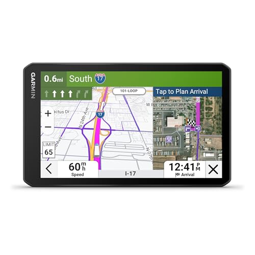
The dezl OTR720 upgrades the experience with a larger 7-inch touchscreen and enhanced arrival planning features. It supports custom truck routing based on size and weight, with alerts for bridge heights and permissions. A major benefit is the ability to view loading docks, truck entrances, and security gates through satellite imagery, enabling more precise docking decisions. While imaging can improve planning, drivers should always verify restrictions and signage on the route to ensure compliance with local rules.
With a broader display, this model improves readability in the cab and supports detailed, multimodal planning for complex deliveries. The birdseye imagery adds a level of overhead context that can be valuable when approaching unfamiliar loading zones or shift changes at large facilities.
Navmoir GPS Navigator: 9-Inch Truck and RV System
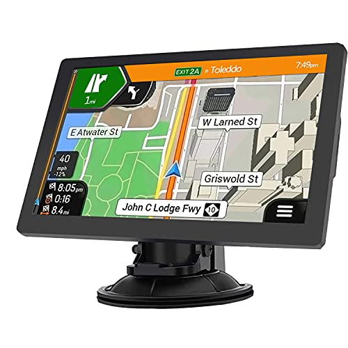
The Navmoir 9-inch navigation system combines a large, readable touchscreen with 2025 maps covering the USA, Canada, and Mexico. It supports custom truck routing by entering precise vehicle size and weight, helping drivers avoid low bridges and narrow roads. The device offers multiple routing modes and search options, including ZIP codes, addresses, favorites, and POIs. Real-time voice alerts, speed and red-light warnings, and lane guidance contribute to safer driving, especially on unfamiliar routes or in urban corridors with complex intersections.
Designed for versatility, Navmoir emphasizes cross-vehicle compatibility, making it suitable for truckers who also operate cars or RVs. While comprehensive, users should verify local restrictions and signage, as routing depends on map data and may not capture every temporary lane closure or detour.
Buying Guide: Key Purchase Considerations
- Route customization: Look for truck-specific routing that accounts for vehicle size, weight, and axle configurations. Check for region-specific availability, as not all features appear in every area.
- Alerts and warnings: Height restrictions, weight limits, tight curves, steep grades, and weigh-station notifications help prevent delays and fines. Assess how comprehensive the alert system is for your typical routes.
- Map updates and coverage: Regular updates (prefer lifetime or annual) and broad geographic coverage (US, Canada, Mexico) reduce divergence between the map and real-world roads.
- Imagery and docking aids: BirdsEye or similar satellite imagery can assist with loading docks and yard access, especially at large facilities. Weigh the value of overhead views against potential data latency.
- Display size and readability: Larger screens improve in-cab readability but may require more dashboard space. Choose a size that matches your truck’s cabin layout and viewing angle.
- Power and installation: Ensure compatibility with 12–24V vehicle power systems, mount compatibility, and ease of installation for fleet use or personal trucks.
- Real-time data: Consider traffic, weather, and road condition feeds. Some devices add fuel price tracking and parking availability, which can aid in route planning and budgeting.
- Additional features: Satellite imagery, dock planning, and a directory of truck services can improve routing confidence. Compare the balance between premium features and price.
When evaluating options, fleets should consider driver familiarity, total cost of ownership, and support for future map updates. Cross-referencing multiple devices that cover overlapping routes can mitigate gaps in any single device’s data. In practice, the best choice often hinges on the driver’s typical routes, preferred screen size, and how much emphasis is placed on yard/dock planning versus street-level routing precision.